


Flash Flood Watch in effect through Thursday
Community, weather October 6, 2021
BLAIRSVILLE, Ga – Union County remains under a flash flood watch until October 7 at 8 p.m.
Much of north Georgia is under the watch including all surrounding counties.
The National Weather Service Office out of Peachtree City (NWS) cautioned residents to pay attention to later forecasts in case they need to take action.
In a longer weather report, NWS stated:
“Rounds of moderate to heavy rain with embedded thunderstorms are expected through Thursday evening. Widespread additional rainfall totals of one to three inches are forecast across the watch area. Locally higher amounts will be possible, especially across north and northeast Georgia. The potential for localized flash flooding and quick rises on rivers and creeks will continue through Thursday, given the wet ground and above normal streamflows across the watch area. Several rivers and creeks have already responded to previous heavy rainfall.”
The weather appears to improve by the weekend.
UCS on two-hour delay pending icy roads tomorrow
Announcements, Community February 15, 2021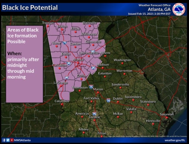
UNION COUNTY, Ga – Union County Schools issued a statement regarding classes on Tuesday, February 16.
“Union County Schools will observe a two-hour delay on Tuesday, February 16, 2021, due to the threat of icy road conditions as issued by the National Weather Service’s Special Weather Statement. Governor Kemp has also issued a two-hour delay for all state offices and buildings. Roads will be evaluated across the district, and any necessary changes with the day’s schedule will be communicated in the morning.”
Additional Delays
Health Department by two hours. – All offices will open at 10:00 am, including ALL Covid-19 vaccination clinics. Persons with appointments scheduled before 10:00 am tomorrow to receive the Covid-19 vaccination will still be vaccinated tomorrow. People with early appointments (before 10:00 am) should come to the clinic when they feel it is safe for travel to receive their vaccination.
Union County Courthouse and County Administrative offices will open at 10:00 a.m. on Tuesday, February 16, 2021 due to the threat of icy road conditions as issued by the National Weather Service’s Special Weather Statement.
Fetch Your News will update this article with any other local closings.
Potential Black Ice as cold front moves through
Community, weather February 15, 2021
BLAIRSVILLE, Ga – The National Weather Service (NWS) warns of black ice and light winter precipitation as the winter storm system that swept the country hits Georgia.
Cold air hit northwest Georgia this morning producing close to freezing temperatures.
NWS Special Weather Statement added:
“As the cold front pushes in behind the storm system this evening, rain could again change to light freezing rain, sleet or snow over far north Georgia. Any accumulations are expected to be very light, however with temperatures falling into the 20s, some roads may become icy from winter precipitation or refreezing of liquid water. The precipitation should end well before sunrise Tuesday morning.”
Counties included in the special weather statement are Dade, Walker, Catoosa, Whitfield, Murray, Fannin, Gilmer, Union, Towns, Chattooga, Gordon, Pickens, Dawson, Lumpkin, and White.
Thunderstorms are possible this afternoon and evenings across north and Georgia. Some might produce strong winds, heavy rain, and lightning in central Georgia.
The cold air probably won’t produce a winter mix until early Tuesday morning.
Winter Storm Warning in effect for North Georgia
Community, weather February 6, 2021
BLAIRSVILLE, Ga – High elevations (1,500 and above) might experience up to three inches of snow overnight. Lower elevations can expect up to an inch of snow.
The Winter Storm Warning lasts throughout the weekend until 12 p.m. on Sunday, February 6 for Union, Towns, Lumpkin, Rabun, and White Counties.
According to the National Weather Service out of Peachtree City, Ga, travel could become difficult from snow on roadways. NWS recommends if traveling to keep a flashlight, food, and water in the vehicle.
Rabun’s expected to bear the brunt of the storm with “heavy snow and sleet expected. Total snow and sleet
accumulations of up to four inches.”
A winter weather advisory is in effect for Fannin, Gilmer, Pickens, and Dawson until Sunday at 12 p.m.
Total snow accumulation could be between one and two inches with possibly more at higher elevations. Only an inch is anticipation at the lower accumulations.
NWS asks drivers to use caution on the roads.
Severe weather expected Sunday afternoon through Monday morning
Featured Stories April 12, 2020
BLAIRSVILLE, Ga – The National Weather Service Peachtree City (NWS) office has issued several severe weather warnings for North Georgia from Sunday into Monday.
From the NWS:
“There is an Enhanced Risk of severe thunderstorms, including tornadoes, across much of north and central Georgia this afternoon through early Monday morning, with a moderate risk for parts of northwest Georgia. Damaging wind gusts and large hail are also likely. Flash flooding will also be possible over parts of far north Georgia this afternoon and overnight. River levels may remain high through early next week.”
A wind advisory also goes into effect at 6 p.m. and will last until 6 a.m. on Monday, April 13. South winds between 15 to 25 mph with gusts up to 35 mph are expected.
NWS warns of possible tree limbs falling and power outages in the area due to the high winds. The service recommends to secure outdoor objects and take caution if operating a “high profile vehicle.”
Finally, North Georgia should be on the lookout for potential flash flooding as a watch will be in place until Monday morning.
“Periods of showers and thunderstorms are expected this afternoon through early Monday morning. Rain will be moderate to heavy at times with localized flooding possible. Rainfall totals of 2 to 4 inches are possible. Runoff from this rain will lead to a threat of flash flooding.” – NWS
Counties included in the issued warning and watches include Union, Towns, Fannin, Murray, Gordon, Lumpkin, Dawson, White, and Pickens.
Feature image from NWS Facebook.
Third Flash Flood Watch within a week for north Georgia
Community, weather February 12, 2020
BLAIRSVILLE, Ga – In this saga of continuous rain, the National Weather Service (NWS) has released yet another Flash Flood Watch for Union and the surrounding counties.
At 9:56 a.m., NWS’s office out of Peachtree City issued this advisement:
“…FLASH FLOOD WATCH REMAINS IN EFFECT FROM 7 PM EST THIS EVENING THROUGH THURSDAY AFTERNOON… The Flash Flood Watch continues for * Portions of north central Georgia…northeast Georgia and northwest Georgia…including the following areas…in north central Georgia…Cherokee…Dawson…Fannin…Gilmer… Lumpkin…Pickens and Union. In northeast Georgia…Towns and White. In northwest Georgia…Bartow…Catoosa…Chattooga… Dade…Floyd…Gordon…Murray…Polk…Walker and Whitfield.
* From 7 PM EST this evening through Thursday afternoon * A cold front will push through Georgia tonight through Thursday. This front will bring another round of locally heavy rainfall to much of north Georgia. Rainfall amounts of one to two inches will be likely, with locally higher amounts possible. Soils remain saturated and several rivers, creeks and streams remain near or in flood, so any additional rainfall will only create run off and exacerbate ongoing flooding conditions. * Flash flooding and minor to moderate flooding of larger creeks and rivers is expected. This will close some roads and could flood homes and businesses in flood-prone areas. Along larger creeks and rivers, flooding could last for several days.
PRECAUTIONARY/PREPAREDNESS ACTIONS…
A Flash Flood Watch means that conditions may develop that lead to flash flooding. Flash flooding is a very dangerous situation. You should monitor later forecasts and be prepared to take action should Flash Flood Warnings be issued.”

NWS’s expected rainfall for the next 24 hours.